Arya Arabshahi

Frames

Short propositions drawn from particular projects. Each states a position, credits the work it comes from, and keeps what was proposed apart from what was built.

Practice note

From the Ecosystemic Belt, Luxembourg, 2023

Where not to build

Where ecological value and development pressure meet, a planning conversation needs a shared picture.
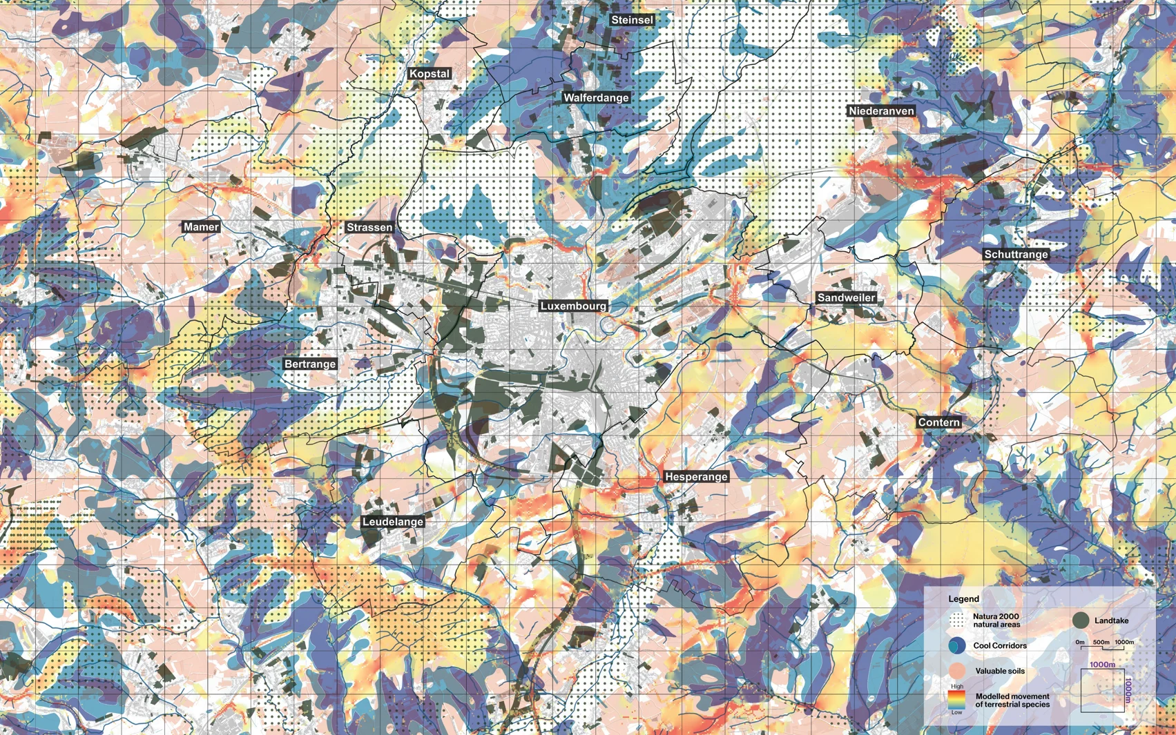
A map of Luxembourg's central agglomeration combining cooling landscapes, soils, natural areas, land take and modelled species movement, with ecological bottlenecks marked.
The ecosystemic portrait of the Agglocentre, with its bottlenecks.

A regional study rarely has the time or the budget to investigate every ecological relationship in equal depth. A useful map has to make a selection, and keep that selection open to question.

For the Ecosystemic Belt we assembled representative indicators of ecosystem services, and of the pressures on them, around Luxembourg's central agglomeration. Cooling landscapes, valuable soils, natural areas, land take and modelled species movement could be read together, and the portrait located the places where several of them meet. We called those places bottlenecks.

A bottleneck is a way to begin a discussion about a particular place. Which service depends on this ground, what pressure could interrupt it, and who has the knowledge and the responsibility to respond? The map ties a regional concern to a situation people can examine together, and it changes the vocabulary of a growth debate. Open land carries functions that belong in the decision beside the demand for development, and once those functions are visible, their protection has a basis for argument.

The atlas was one part of the study. Interviews and field sessions brought knowledge the spatial layers could not hold. The indicators are representative, the movement patterns are modelled and the proposed protections are recommendations, and reading the map well means keeping those distinctions in view.

From the Ecosystemic Belt, by 51N4E with 2001, LOLA and specialist collaborators, for the Ministry of Energy and Spatial Planning. I framed and led 51N4E's contribution.
Proposition

From Grande Porte des Alpes, Lyon, 2022 to 2025

Compaction zones

A growth strategy can begin with the capacity of places already occupied.

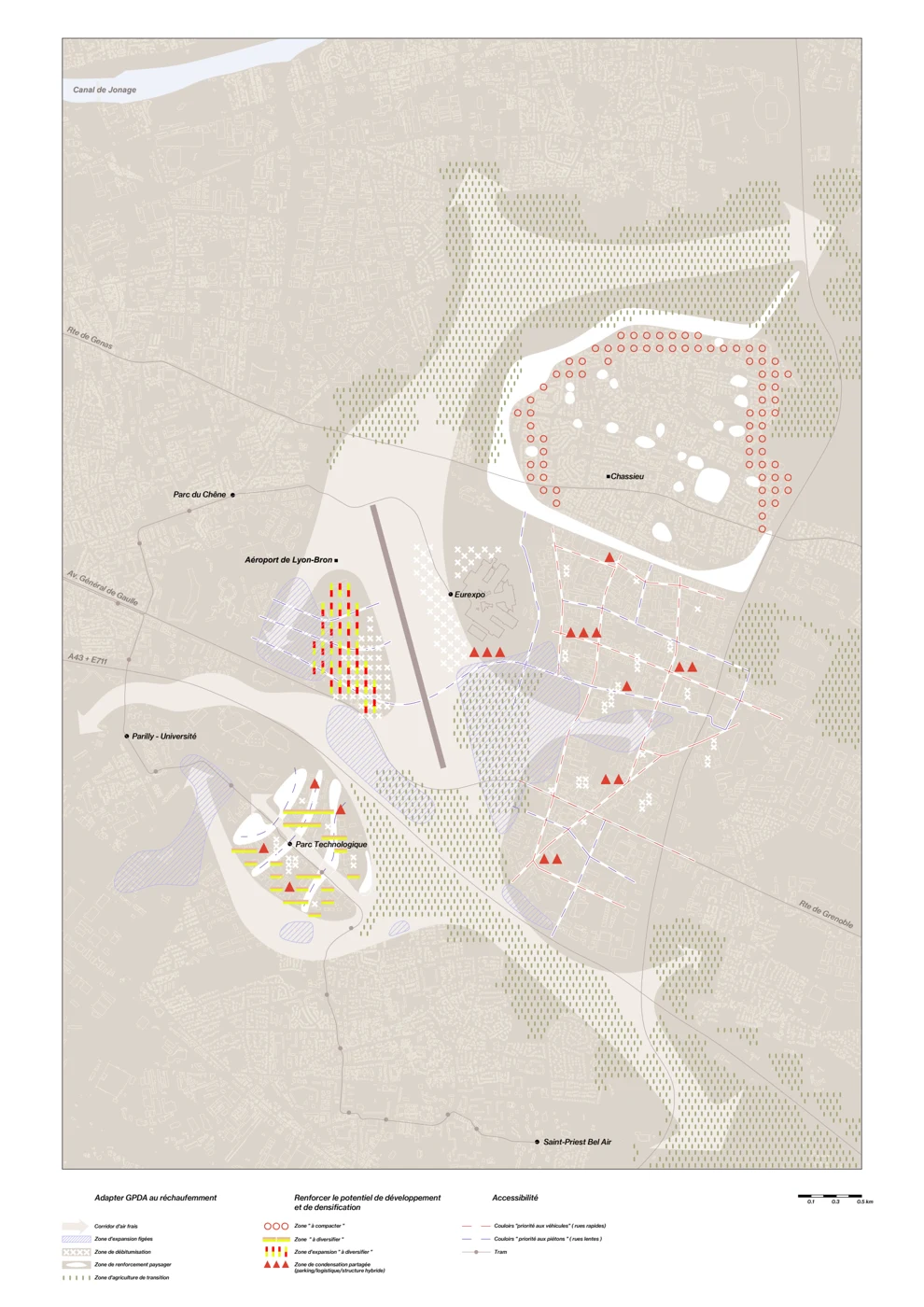
An illustrative zoning map synthesising the territorial proposal for Grande Porte des Alpes.
Illustrative zoning, a territorial synthesis of the proposal.

Expansion zones are a familiar instrument. They reserve ground for future development and make growth legible on a plan. East of Lyon, the expansion zones planned on virgin soil lay over the last cool pockets of the territory, ground that would stop cooling the day it was built on.

In Grande Porte des Alpes we proposed to keep those surfaces open and to place growth over what was already sealed. More than a third of the territory faced obsolescence, in uses falling out of demand, in buildings below today's structural and energy baselines, and in farming and ways of life that rising heat and drought could no longer sustain. In the Parc Technologique alone, close to 35,000 of 200,000 square metres of rentable space stood vacant, beside some 6,000 parking spaces that were mostly empty. We called the instrument a compaction zone. It takes the place of an expansion zone on the plan, over sealed surfaces and within underused, high-vacancy fabric.

The line on the plan is the simple part. What makes compaction work happens inside it, in vacant floors let on short contracts, shared facilities paid for by use, sealed ground opened to planting, and agreements across plots that no single owner can make. The term gives that collective task a spatial identity, and a place on the plan where it can be negotiated.

These were proposals in a strategic study. The next test belongs to particular sites, their climate, their users, their owners and their capacity for change. The Métropole has since commissioned masterplans for two of the four areas.

From Grande Porte des Alpes, by 51N4E with 2001, LOLA and Ville Ouverte, for the Métropole de Lyon. I led and reshaped 51N4E's four climate-adaptive visions. Climatic maps and renders by 2001, climatic model by LOLA.

Open question

From the Greenbelt, Luxembourg, 2023

Systems of nature, systems of governance

A shared landscape brings responsibilities together before institutions do.

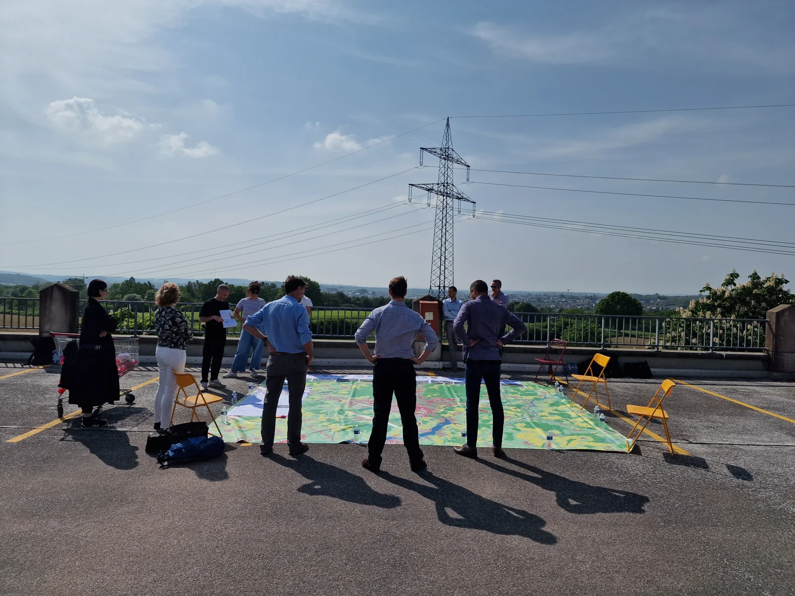
Participants in a Greenbelt work session gathered around a large territorial map.
A Greenbelt work session around a territorial map, 2023.

A territory can support food production, cooling, movement, biodiversity and recreation on the same ground. Those functions connect places that are governed through different departments, mandates and planning instruments.

In the Ecosystemic Belt, reading the services together made the overlap visible. It also raised a question about the institutions that would act on the picture, since a shared diagnosis does not by itself settle who will maintain a place, finance an intervention or resolve a disagreement.

Maps can show where services and pressures meet. Field sessions add the people who know, use and manage those places, and together they reveal the spatial opportunity and the responsibilities around it. The next step is to ask what each institution can decide, which commitments have to be shared, and how those commitments can outlast a change of personnel or of government.

Several Greenbelt pilots passed to the Agglocentre authorities. Others stalled after the minister left office. Strong analysis and a ministerial champion had not secured durable ownership, maintenance and financing across the institutions that remained, and since then I treat all three as design questions from the first stage of a project. This note opens the question through one experience. A tested governance model is the work still to do.

From the Ecosystemic Belt, by 51N4E with 2001, LOLA and specialist collaborators. I led 51N4E's contribution, secured the Vital Belt extension and curated the exhibition.